

“If it weren’t for Moab, I wouldn’t be in Utah altogether!”
Scott* nearly has to shout to make himself heard, while he is driving us through Utah’s desert in an old-school pickup truck. Tony Diesel, his truck, has the same red-rust colors as Moab’s mountains. It seems nearly as old as well, but a little shaking here, a pat on the hood there does its job. Tony Diesel is still running.
We are on our way to the Labyrinth Canyon west of Moab, where the Green River carves its way deep and deeper into the Colorado Plateau. We will follow the meandering river from Crystal Geyser near the town Green River (river mile 116) to Mineral Bottom at the entrance of Canyonlands National Park (mile 52) – an easy four-day trip which leaves plenty of time to chill at camp sites and hike into the canyons.

“If it weren’t for Moab…”
The town of 5,000 inhabitants in eastern Utah is the hub to two national parks (Arches and Canyonlands) and a center of outdoor sports in the American West, especially for climbing, highlining, mountain biking, and canoeing. Scott came to Moab as a “refugee” as he says with a grin – having fled his native Northern Utah “where the Church has all the say”. Sixty percent of Utah’s inhabitants are Mormons, especially in rural areas and Salt Lake City where the LDS church has its headquarters.
But Scott, driver and tour guide for a Moab-based outfitter, loves Utah as much as he hates it. “You can go wild here! “ While we judder on, he explains how the state managed to keep its land mostly public and accessible for all. Unlike Colorado, whose inhabitants often come to Utah for outdoor sports as he says, because so much of their wilderness area is privatized.
You can go wild here!
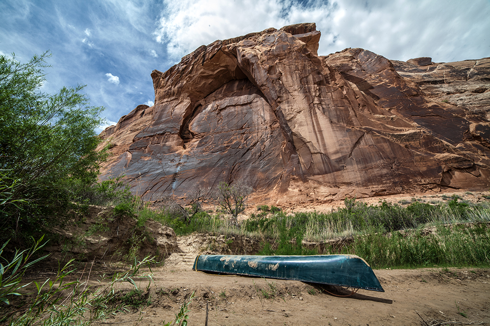
Scott’s voice echoes in our minds after having been dropped in Crystal Geyser an hour later. We see no geyser, the Green River looks muddy-brown and the wilderness is a wasteland of rubble. No red buttes and mesas, no canyon walls, nothing. We look at each other, at the lonely canoe, and shrug: What else could we do?
For half a day, few bushes and no walls provide shade. There is only one advantage of starting that far upstream: You will cherish the beauty of the Labyrinth Canyon even more!
(Note: Don’t be like us. Don’t start at Crystal Geyser. Leapfrog that paragraph and those hours: Start at Ruby Ranch 19 miles further downstream and paddle beyond Mineral Bottom into the Stillwater Canyon, if you can.)
Slowly the walls build up: The piles of rubble rise after every bend, soon the first mesa appears and finally walls protrude 20, 50, 100 yards high from the river. They take us on a journey through geological eras. The oldest layers of rock are on the bottom, the youngest on top and prone to erosion. There are 22 of them, carmine, pink and orange, white and shale and grey: Paradox and Honaker which have been around for 1.7 billion years. The younger Halgaito and Cedar Mesa Sandstone. Next the Moenkopi and Chinle Formation. Wingate and Kayenta. And last but not least Navajo Sandstone with its famous red color. Tony Diesel red.

19th century graffiti
The canyon walls glide past us, polished and noble verticals. As climbers we cannot help but wonder whether they are “doable” and for whom. We settle for “5.13, 5.14“, near the top of the contemporary climbing scale, and give up the thought.
These walls carry entire ecosystems as well as messages of old times. There are small holes (for spiders), big holes (for ourselves), holes in holes; there are bird nests glued to the wall and semi-circular amphitheaters which could become concert halls for thousands of listening paddlers. Well, theoretically.

The French trapper Denis Julien was the first who, in 1836, recorded his way along the river. Every few weeks he would leave his name, date and some rather awkward drawings on the canyon walls – the further up the later the date. Why he headed against the stream nobody knows. Nowadays leaving marks on the walls is illegal, but the message is lost on some river-dwellers, who “ornate” the billion-year-old walls and even left their hearts and arrows on top of Julien’s historic writing.
We spend a long time in vain looking for Navajo paintings which are located in smaller side canyons. Instead we find gigantic drawings all over the walls, like that 10-yard-high profile of an old Indian woman with a child at her side, surrounded by waves – “drawings” produced by the forces of nature and completed in our imagination.
Stone blocks as large as houses lie in perfect balance on the scree slope beneath the canyon walls, while we pass beneath. Further on we see another such block inside the water, crashed, like the head of a statue whose era has ended. Lucky those who were not passing by when it happened.
Very rarely, we meet a kayak, raft and even a family of 20 people. While the walls amplify all sounds within our stretch of the river – between the bend behind and the bend ahead of us – they shade off any other sounds. We are alone.

Surreal companions
Alone and surrounded by other animals who make it clear that this is their element, not ours:
– The ghost bird whose large shadow strides across the canyon wall a hundred yards above us, while the bird itself remains invisible.
– Spiders! When I let my headlamp illuminate the beach where we put our tent at night, two phosphorus eyes reflect it back on me. A dark body works its way up the sand. Why do they have to start their day while we finish ours around a campfire?
– And Comedy Bird: I have never seen it and don’t know its real name, but it lives all over the American Wild West, from Tuolumne Meadows to the Grand Canyon. All it does is sing wrong minor scales downwards. It sounds like the public laughter in a comedy sitcom or a falling rock in slow motion. Does it make fun of us or is it just the least musical bird species out there?
Beware the bend!
 Shall we go or shall we stay? Yes, we have noticed the dark clouds and the fact that other paddlers were putting up their tents on uncomfortable brushwood slopes around noon. But we want a beach to camp on, and we are optimists. So we head out of the bay and onto the calm muddy waters. When we paddle around the bend we see a wall of waves rushing toward us – too late to react, just early enough to regret our decision. The canyon has shaded us off in the lee only to channel the storm toward us around the bend. Lightning strikes and we paddle furiously for an eternal 15 minutes until we reach a shore with dense reed in which we can sit out the thunderstorm.
A sudden storm, a sudden silence. Another storm, another silence. A wave of heat, of cold. On the Green River you can never be sure what to wear, where to stop. Due to its labyrinthine geography it can be lazy and comforting for hours, just to turn into a wrathful snake in seconds.

Stone people, unmusical birds
All too early in the morning, the birds of Canyonlands bounce back to life. What I hear is too captivating – or enervating – to fall asleep again. DJ Bird provides the rhythms: Chh-tak, chh-tak, chh-tak. A second bird joins in with irregular interjections, eager to contribute to the concert but too unmusical to keep up with the DJ’s pace. Impatient with the lame locals, a bunch of geese take over, cosmopolitans in transit down on the river. “Red red red” beaks the first, “rocks” answers her companion. “Red rocks”, the canyon walls echo back. But the river takes them downstream as fast as they appeared and the local band resumes their concert, only occasionally joined by a faint “red rocks” in the distance. Once they have found their rhythm, another exotic bird interrupts: “Didididit didididit”. Sorry, guys, that’s our alarm clock.
In some bends with particularly good views, stone people protrude from the wall high above the river, one pillar next to another, their noses, hairstyles and legs well defined. Some of those guardians seem to put their heads together, amused and utterly unimpressed by the river’s minute-by-minute happenings.
They have seen entire eras evolve and decay after all.
*name changed for anonymity

When to go: Spring and fall are ideal times for canoeing, as the water levels are low enough to camp on exposed sand banks. If you plan to do the trip in summer, be prepared for severe heat and thunderstorms in the afternoons. Avoid Easter, Labor Day and especially the Memorial Day Weekend (motorboat event) if you want to enjoy tranquility. In winter there may be ice on the river.
Where to go: If you can, extend your trip by paddling into the National Park – you need a (restricted) permit and an outfitter that can bring you back to Mineral Bottom on a jet boat as there is no landing in the park. We couldn’t get the latter – to be booked months in advance! If you can’t, no problem: Although the Labyrinth Canyon doesn’t officially belong to the National Park, the last part is just as impressive as the park itself.

What to read: Labyrinth Canyon is on BLM land, so the website of the Bureau for Land Management is a good source of information. They offer a digital map for a brief overview, but you will need a river guide book with a more detailed map. Local outfitters recommend this one and we found it exact and entertaining – you can buy it online or in the Moab Tourist Center: Belknap’s Waterproof Canyonlands River Guide. 78 pages, scale: ca 1:50.000, revised 2014, $19,95.

What to rent: We rented the canoe, equipment – including the mandatory river toilet – and got a transit to the river and back from Moab Rafting and Canoe Company. Their owner Theresa has been on the Green River hundreds of times and also offers guided tours. We were happy with MR as they are reliable and great people. They are a little more expensive than some of their Moab competitors, but the latter were booked out a month in advance. You might want to compare the alternatives though: Canyon Voyages, Tag-A-Long Tours and Tex’s Riverways.
What to take: map, extra rope (to tie equipment in the kayak); water sandals, hat, raincoat, fleece sweater; insect repellent, lip balm, sunscreen and sunglasses; tent, sleeping bag, inlet, sleeping pad, one headlamp with spare batteries per person; toilet paper and hand sanitizer; drinking water for the entire trip; dry food, stove and pot; first aid kit; possibly a satellite beacon. The area is remote: There are no streets or settlements and no cell phone service within the canyon. You must be self-reliant to deal with emergencies.

What to prepare: Check the weather forecast and the water levels ahead of the trip or ask the outfitter. Print your free permit: http://www.blm.gov/ut/st/en/fo/moab/recreation/River_Recreation/LabyrinthCanyon.html While BML plans to restrict how many people can access the Labyrinth Canyon in the future, the permits are still unlimited. If you decide to paddle further downstream into the Canyonlands National Park, however, permit restrictions apply.

What else to do on such a long journey? If you are driving, you can combine Moab with visiting the Grand Canyon in Arizona, Joshua Tree or Death Valley in California, or some of the five National Parks in Utah – the South West has a lot to offer. If you want to hear about the Mormons from their own perspective, you can book a free temple tour in Salt Lake City.
What is a landscape you care about? Let me know in the Instagram comments!
Sieh dir diesen Beitrag auf Instagram an